

Department of Urban Planning and Public Policy · UC Irvine
We study the spatial organization of neighborhoods, cities, and regions.
Spatial methods for urban processes, open science for public decisions.
SSUS is the research lab of Elijah Knaap at the University of California, Irvine. We draw on urban economics, sociology, and geography to explain why activity concentrates where it does, how places change, and who gains or loses as they do.
People and places are connected and interdependent. Understanding network structure and relationships embedded in space requires formal geographic models: we develop spatial econometric and Bayesian models of spillovers, sorting, and flows, and the sparse numerical tools that make them feasible for whole metropolitan regions.
Research areas
Structure and Form
How land, housing, and jobs are arranged across a region.
- Land and housing markets
- Economic geography
- Agglomeration
- Urban form
Sorting and Change
Who lives where, and how neighborhoods change.
- Residential sorting
- Segregation
- Neighborhood change
- Neighborhood effects
Access and Policy
Who can reach what, and how public decisions change it.
- Access to opportunity
- Schools
- Public health
- Transportation
- Fair housing
How We Work
- Spatial econometrics
- Spatial statistics
- Bayesian estimation at scale
- Discrete choice models
- Measurement models
- Areal interpolation
- Regionalization
- Network accessibility
- Open-source software
From the work
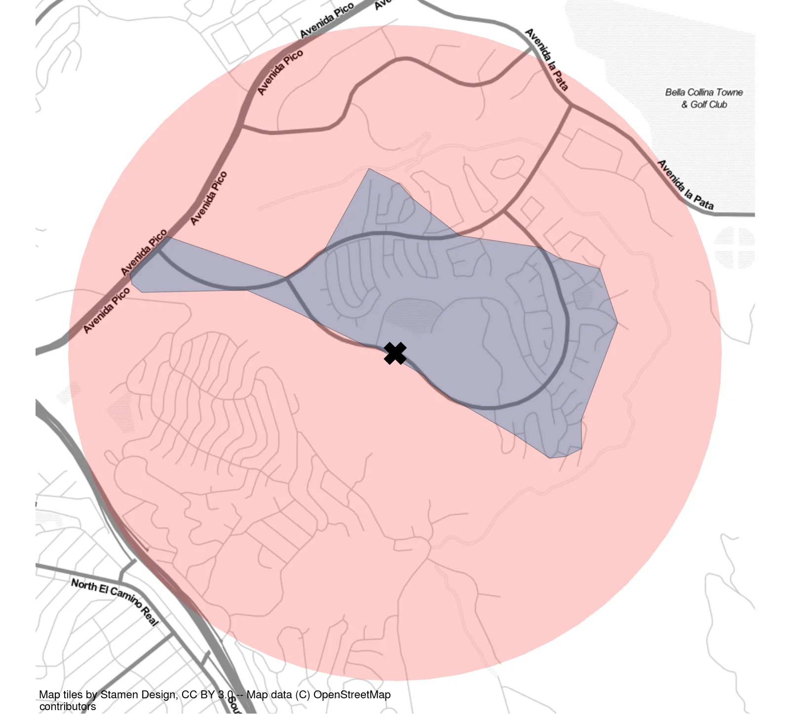
A neighborhood is what you can walk to
Segregation indices usually draw each neighborhood as a circle. Measured along the street network instead, the neighborhood shrinks to the streets a person can actually reach — and with it the city's measured segregation: across all 380 U.S. metropolitan areas, the network-based measure runs about 20 percent higher, and the gap is widest where streets are winding and sparsely connected.
Read the paper in Environment and Planning BThe book
Urban Analysis & Spatial Science
Theory, Methods, & Code for Studying Neighborhoods, Cities, & Regions
Knaap's textbook introduces the theory and intermediate quantitative methods of urban and regional analysis as a series of executable computational notebooks in Python. Each chapter takes a topic from the social science and policy literature and carries out a real analysis step by step.
Read the draft- Spatial Data
- Interpolation and Change of Support
- Spatial Analysis
- Accessibility and Interaction
- Urban Spatial Structure
- Segregation
- Urban Factor Models
- Neighborhood Delineation
- Neighborhood Change
- Spatial Econometrics
- Location Models
News
All newsUpcoming
PySAL workshop and new segregation research at NARSC, PhiladelphiaKnaap and Sergio Rey teach Spatial Data Analysis and Econometrics with PySAL on the first day of the North American Regional Science Council’s annual meeting, November 11–14, and Knaap presents Separated, Polarized, and Factioned?
Release
pandarm 0.0.7The pandas routing machine: travel network analysis on contraction hierarchies, with a pandas interface.
News
Knaap joins the editorial board of Regional Science Policy & Practice
Projects
All projectsCurrent
Spatial Concordance Indices of Income Segregation
A new spatial segregation index that locates where in a region's income distribution its geography is most organized.
Current
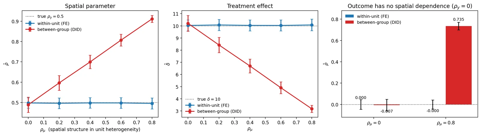
Space Is Not a Control Group: Quasi-Experimental Design in the Presence of Spatial Dependence
Why difference-in-differences cannot recover the effect of a treatment defined by location, and the spatial fixed-effects design that can.
Current
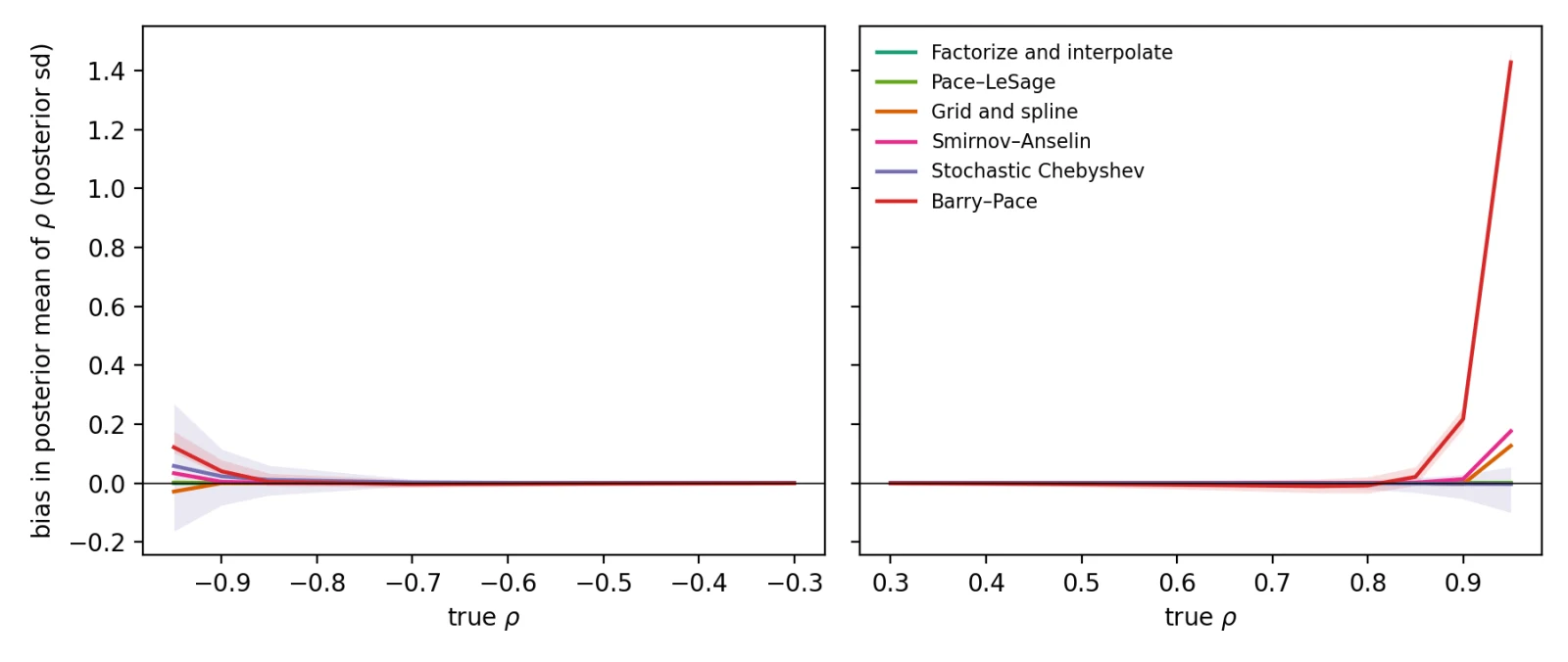
Fast and Unbiased Log-Determinants for Large Spatial Autoregressive Models
Log-determinant methods that make Bayesian spatial autoregressive models fast and unbiased at the scale of every U.S. census tract.
Selected publications
All publications- 2026
- 2025
- 2024
- 2024